Managing Layers
The Layers panel on the left lists every layer in the project, from the topmost drawing layer down to the basemap. Selecting a layer here drives the Style panel and the Attribute table.
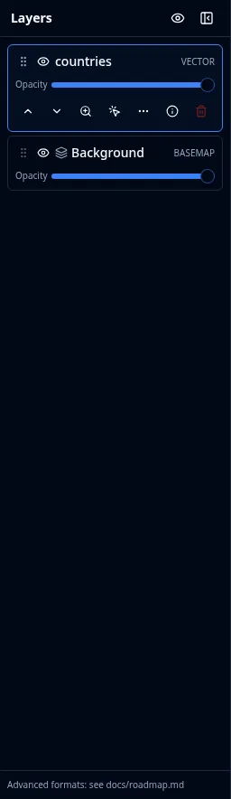
Layer order and visibility
- Visibility: click the eye button to show or hide a layer. The Hide all layers button at the top of the panel hides every layer at once.
- Order: drag a layer to reorder it, or use the move up and move down actions. Layers higher in the list draw on top. The basemap (Background) always stays at the bottom.
- Opacity: each layer has an opacity slider from 0 to 100 percent.
Per-layer actions
Each layer exposes a set of actions:
- Zoom to layer: fit the map to the layer's extent (for layers whose bounds are known).
- Identify features: click features on the map to see their attributes in a popup.
- Labels: toggle text labels for vector layers that have a label field.
- Metadata / Properties: inspect the layer's source and configuration.
- Remove layer: delete the layer from the project.
- Insert before: control where a new layer is placed in the stack.
Layer groups
Groups are folders in the layer stack. They can nest, so a project can carry a real hierarchy rather than one flat list.
- Create: New group adds an empty folder. New group from layer wraps the layer you are on, and New group from selected layers wraps a multi-selection.
- Fill: Move to group moves one layer, Move selected layers to group moves a whole selection in one step (keeping their relative order), and Add data to group opens Add Data with the new layer targeted at that group.
- Organize: rename a group, collapse or expand it, move it up or down, and set a group-level opacity that applies to everything inside.
- Visibility: hiding a group hides its layers. A layer inside a hidden group is marked Hidden because its group is not visible, so you can tell it apart from a layer you turned off yourself.
- Remove: Ungroup (keep layers) dissolves the folder and leaves its layers in place; Delete group and layers removes both.
Groups and their nesting are saved with the project, and importing a QGIS project brings that project's group tree across.
Refreshing live layers
WFS and GeoJSON URL layers can refresh automatically so the map stays current with a changing source. Open the layer's refresh configuration and choose an interval (for example off, 15 seconds, 30 seconds, 1 minute, 5 minutes, 15 minutes, or a custom value), or trigger a manual refresh.
Each reloadable layer persists a connection record with the project, so the refresh cadence survives a save and reopen. The record also carries the layer's synchronization status — when it last succeeded and the most recent error — which the Layers panel shows, and an on-failure policy that decides whether a failed refresh keeps the last good data or clears it. See Project Format for the schema.
DuckDB layers
Layers added from a DuckDB source or produced by the SQL Workspace support identify, selection, and the attribute table like any vector layer. You can also materialize a DuckDB query result into an editable GeoJSON layer when you want to edit its geometry or attributes.
The basemap
The Background entry at the bottom of the panel is the basemap. Toggle its visibility and adjust its opacity here. To change which basemap is shown, use the Basemaps plugin from the Plugins menu. See Adding Data.
Editing geometry
To draw or edit features directly on the map, activate the GeoEditor plugin from the Plugins menu. It adds drawing, vertex editing, and deletion tools for GeoJSON layers.